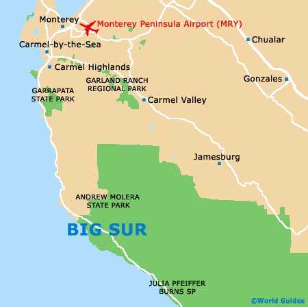
Big Sur Maps and Orientation
(Big Sur, Monterey County, California - CA, USA)
Sandwiched between some of California's biggest and most visited cities, Big Sur is within reach of iconic destinations, with
San Francisco and
San Jose lying to the north, while
Los Angeles and
Long Beach can be found to the south, well connected by the coastal Highway 1.
Big Sur encompasses a vast area of expansive wilderness and resides alongside the beautiful shoreline of the Pacific Ocean, within the central region of sunny California and close to the famous Santa Lucia Mountains. The Cone Peak is a familiar sight in Big Sur and this towering mountain is amongst the tallest in the whole of the USA.
Maps and Orientation of the City
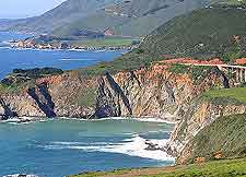
Highway 1 is often referred to as the Pacific Coast Highway and connects Big Sur to many neighboring places of interest, both north and south. Particularly close by is the holiday resort of Carmel-by-the-Sea, which lies just minutes away and on the northerly outskirts of this region.
As you drive along the US Highway, you will find maps of the Big Sur region very useful, especially if you plan to stop off along the way to enjoy the beautiful views from the roadside.
- Anaheim - 330 miles / 531 km (five hours and 50 minutes, southeast)
- Carmel-by-the-Sea (Carmel) - 26 miles / 42 km (35 minutes, north)
- Fresno - 180 miles / 290 km (three hours and 20 minutes, east)
- Greenfield - 70 miles / 113 km (one hour and 25 minutes, east)
- Long Beach - 325 miles / 523 km (five hours and 40 minutes, southeast)
- Los Angeles - 305 miles / 491 km (five hours and 20 minutes, southeast)
- Marina - 39 miles / 63 km (50 minutes, north)
- Monterey - 29 miles / 47 km (40 minutes, north)
- Oakland - 140 miles / 225 km (two hours and 40 minutes, north)
- Pacific Grove - 30 miles / 48 km (40 minutes, north)
- Pinnacles National Monument - 75 miles / 121 km (one hour and 30 minutes, east)
- Salinas - 47 miles / 76 km (one hour, north)
- San Francisco - 148 miles / 238 km (two hours and 50 minutes, north)
- San Jose - 100 miles / 161 km (one hour and 50 minutes, north)
- Santa Barbara - 210 miles / 338 km (three hours and 45 minutes, southeast)
- Sacramento - 216 miles / 348 km (four hours and 20 minutes, northeast)
- Santa Cruz - 70 miles / 113 km (one hour and 20 minutes, north)
- Santa Maria - 139 miles / 224 km (two hours and 40 minutes, southeast)
- Sunnyvale - 110 miles / 177 km (two hours, north)
- Watsonville - 55 miles / 89 km (one hour and 15 minutes, north)
Map of the United States

Map of California

Map of Big Sur